Your express stop for the latest Sound Transit news

Crosslake Explained: Tracking wind and wave conditions on a floating bridge
An innovative new monitoring system makes 2 Line service across Lake Washington possible.
The Homer M. Hadley floating bridge is an engineering landmark in the Puget Sound region. Measuring 5,811 feet, it’s the fifth-longest floating bridge of its kind in the world.
The structure is supported by a series of connected pontoons — massive hollow concrete boxes that float on the surface of the water, allowing the bridge to span Lake Washington without resting on the lakebed. This design is key to making long crossings possible in deep or soft-bottomed bodies of water.
Constantly exposed to environmental forces like wind and waves, the bridge is designed to handle three types of movement across six directions. This flexibility is essential for maintaining stability and performance under dynamic conditions.
Engineers also had to consider a variety of weight sources on the bridge, which carries both the westbound lanes of I-90 and the Link 2 Line’s light rail tracks in both directions.
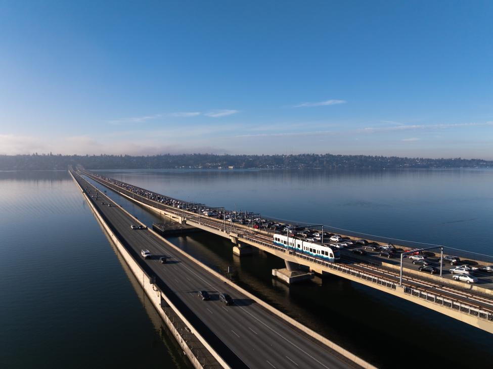
When more weight is concentrated on one side, that section of the bridge lowers, while the opposite side lifts. Uneven loads like this can create additional stress on the structure. That’s why Sound Transit only runs two Link trains, traveling on opposite tracks, on the bridge at the same time.
The Washington State Department of Transportation owns the Homer M. Hadley bridge, and Sound Transit’s strong partnership with WSDOT ensures we keep stress levels as low as possible to prevent cracks and leaks and keep the structure watertight.
Innovation for operations
At more than 22 miles long, the glacially carved Lake Washington is the second-largest natural lake in the state.
Strong winds blowing across such a big body of open water for an extended period can build up significant waves that create stress on the bridge.
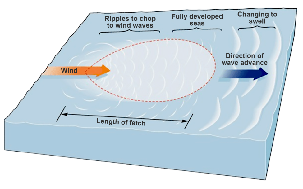
Most frequently, these winds blow across the lake from the south, which means they don’t directly impact the Homer M. Hadley bridge.
That’s because its sister structure, the Lacey V. Murrow floating bridge, which carries the eastbound lanes of I-90, is located just a couple hundred feet to the south. This bridge absorbs the most common southerly waves, creating a breakwater effect that helps protect the bridge carrying light rail.
Strong winds coming across Lake Washington from the north are much more rare.
But Sound Transit’s light rail system is still designed with these conditions in mind, with an innovative Wind and Wave Monitoring System to inform operational status and decisions.
Prepared for rare conditions
Now that the full 2 Line is open and carrying thousands of riders across the lake every day, wind speed and wave height are two key factors that influence service.
Meteorological devices called anemometers are installed on the north side of the rail alignment on the Homer M. Hadley bridge to measure wind speed, direction, and duration, which build wave height. These anemometers are connected to computers, which collect the data and perform calculations to estimate wave height.
If conditions meet certain thresholds, the computers send a signal to Sound Transit’s operational technology systems, which work together to monitor, alert, and control critical aspects of light rail service.
If waves grow to certain thresholds, we’ll temporarily adjust 2 Line service over the bridge.
Here’s what you can expect:
- As wind blows steadily, the water surface changes from ripples to waves, and the longer this goes on, the taller the waves get. Small waves (measuring under 1.4 feet) don’t trigger alerts and don’t affect operations. Trains run as usual across the lake.
- Sustained winds from the north at 30 miles per hour for at least 83 minutes can create an approximate wave height of 1.5 feet in this area of Lake Washington. This is when the system would tell our control center to scale back to one train on the bridge at a time, rather than two. Reducing the weight on the bridge will help reduce the stress while wave conditions are rough.
- If the wind continues to blow from the north (sustained at about 40 mph for 71 minutes) and we reach an estimated wave height of 2.21 feet, we’ll temporarily suspend service across the bridge until conditions improve.
This is all in place to make sure that the bridge remains in a low-stress state, prolonging its lifespan for many years to come.
Sound Transit’s Wind and Wave Monitoring System is built with redundancy, so if one sensor triggers an alarm (for instance, if a bird hits an anemometer) but the other doesn’t, it can tell it’s likely not weather related.
Tracking wind and waves is just one new facet of operating a truly regional light rail system in our unique and beautiful part of the world.
While we expect severe conditions affecting service will be very rare, protecting the bridge infrastructure and our passengers will always be our top priority.
Do you ride Link? Be sure to sign up for rider alerts so you never miss a service update!